Backpacking in the Pere Marquette State Forest (Michigan)

Michigan is such a beautiful state! I find myself returning again and again.
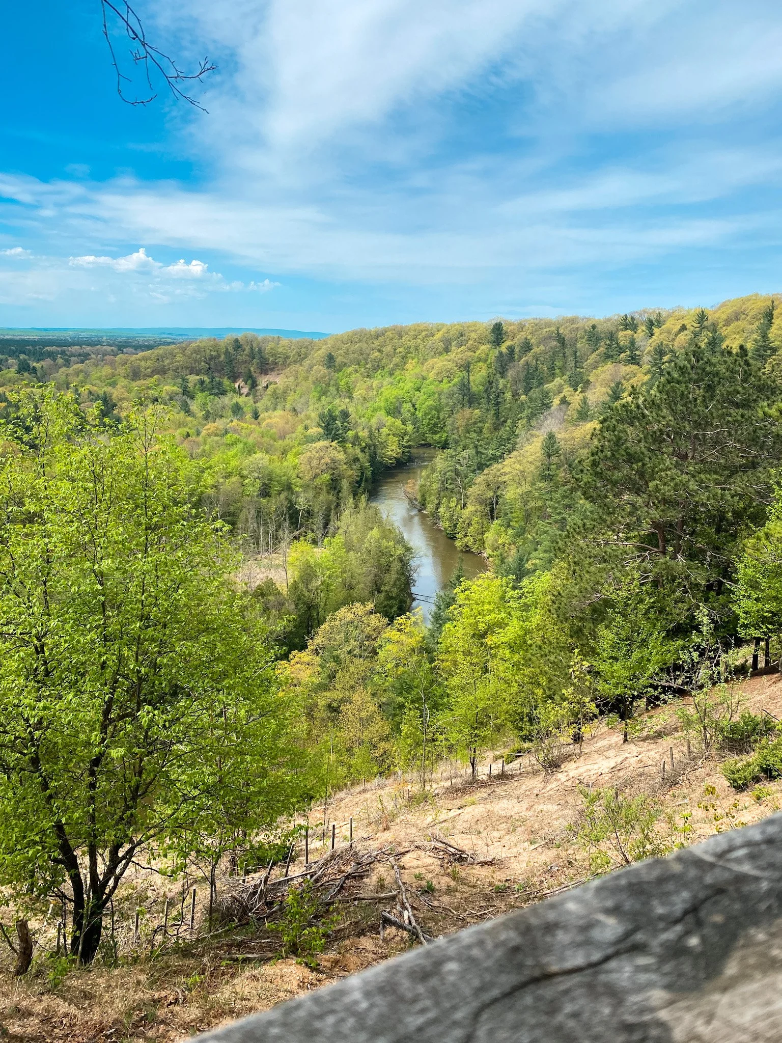
You may have heard of the Manistee River Trail Loop, which is an iconic Midwest backpacking trip that traverses 23 miles along the Manistee River using the Manistee River Trail and North Country Trail. When I set out to embark on my first-ever backpacking weekend it was on my shortlist, but I ended up on this alternative instead. This hike takes place just north of the MRT Loop in the Pere Marquette State Forest. It’s a beautiful natural preserve of red pine forest with the Manistee River winding through it.
If you’ve already done the Manistee River Trail Loop and are looking to enjoy something different, this is a great option. And if you’re keeping track of North Country Trail mileage, you’ll cover MI-781 to MI-765.5.
To help you explore it yourself, I’ve put together this detailed backpacking itinerary.

Know Before You Go
Permits:
You need to have a Recreation Passport displayed in your vehicles. More info here.
Other than the sticker for your vehicle, no other permit is required to hike or camp on this route. Dispersed and Primitive tent camping within the Forests is allowed almost anywhere, unless otherwise posted closed and/or "No Camping".
Specialized equipment:
A water filter is required.
The 10 essentials (always)
Hiking poles are recommended.
A bear canister is recommended. Canisters typically hold 3-5 days’ worth of food and toiletries for 1 person, making them ideal for a trip like this. But you can hang a bear bag as an alternative.
Navigation:
The trail is pretty straightforward and can probably be done without a trail map. However, I’ve created a map you can use with AllTrails to navigate if you wish. I always feel safer hiking with my AllTrails running in case I get off trail! Plus, I’ve included waypoints for some historic spots so you won’t miss them, as well as good spots to camp each night so you don’t have to spend too much time figuring that out.
Contact me to get the GPX map and instructions for how to use it!
Planning:
Check what time the sun sets on the first day of your hike. You’ll need 2-3 hours for hiking and at least an hour to set up your camp and make /clean up dinner. Longer if you’re hanging a bear bag! Make sure you plan your day so you arrive at the trailhead ready to hike at least 4 hours before sunset.
Review Leave No Trace principles.
Review the 5 W’s of making a backcountry camp.
How difficult is the hike?
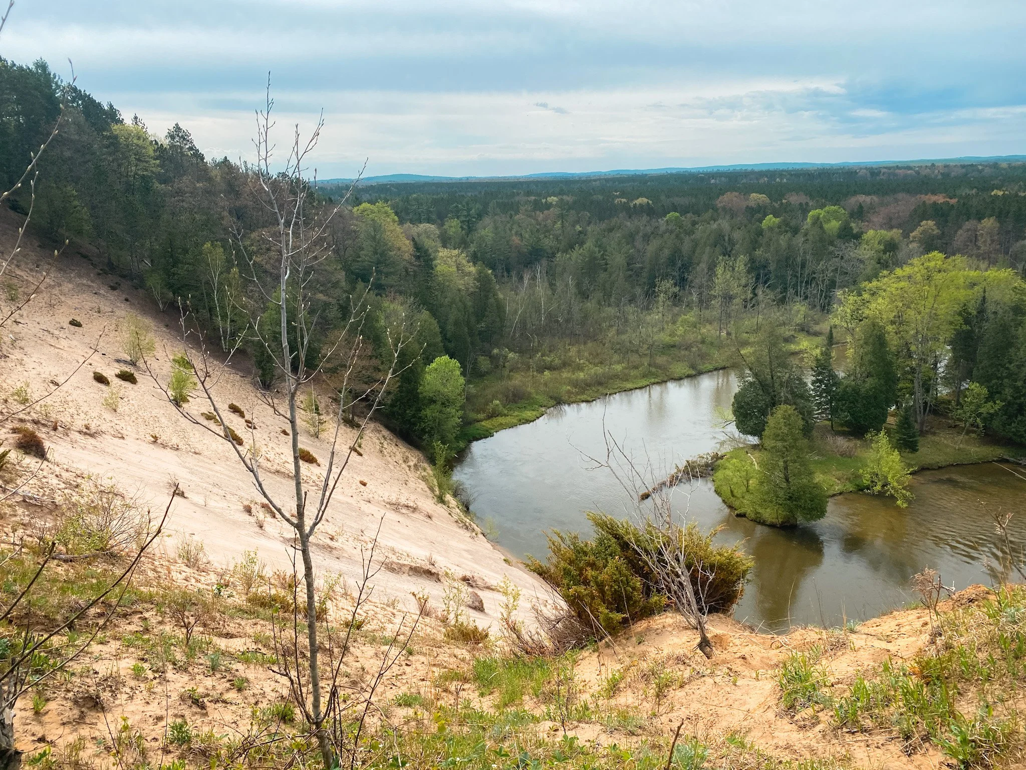
This is an easy to moderate route as far as backpacking goes. The hike is 19 miles, so taken over a few days the mileage is relatively low. However, you will mostly be hiking up on the bluffs above the river. There are inherent dangers to this and you should stay on the trail, away from the edge. At times the trail narrows and becomes steep. There are also times when active forestry may force you off the trail and you will need to pay attention to the detour signage.
Be mindful of filling up on water at times when you have access. Much of the hike takes place well above the water with no ability to hike down. Come prepared to filter your water as you will be drinking from the river.
Alright, let’s get hiking!
Day 1 - Manistee River
Mileage: 3.5miles
Drive one car to the end point at Baxter Bridge. In whatever app you use for maps, pull up Old 131 state forest canoe pull out to navigate there. Make sure you have your Recreation Passport displayed in your vehicle. NEVER LEAVE VALUABLES IN YOUR VEHICLE.
With all of your gear and hikers, drive your second car to the parking lot at 12 and 15 Roads here. You must have a Recreation Passport here as well.
Look for the North Country Trail sign. You’re off! Make sure the start AllTrails if you’re using it.
Following the Manistee River along it’s many switchbacks, you’ll have lots of opportunities for incredible views and photos. Prior to setting out, I hadn’t realized just how many switchbacks there were. The first time we came to a spot with that Horseshoe Bend look, I thought it was THE one I had seen in so many photos. But I soon realized there were many spots that looked like that!
When you get to Waypoint 1 / Night 1 Camp on the AllTrails map, stop and make camp. You will have a short climb down to water, so take care of your water collection and filtration first and then just enjoy your beautiful campsite.
Day 2 - The Harvey Bridge
Mileage: 9miles
Wake up and start hiking!
On the way you’ll pass the historic Harvey Bridge. Northern lower Michigan has an extremely small number of remaining metal truss bridges, which makes this one special. It’s also a popular spot for paddlers to launch from.
When you get to waypoint 4 on the map, stop and make camp. If there are already people here, you will need to collect and filter water, then head up the hill (it’s a steep hike!) to Waypoint 3 instead.
Day 3 - High Banks Rollaway
Mileage: 6.5miles
Wake up and start hiking!
Today you’ll come to the Manistee River High Banks Rollaway, which got its name because of the thousands of logs lumberjacks would stockpile along the river during the winter months. When the ice broke up in the spring, key logs were removed, causing the pile of logs to roll down the bank into the river to begin their trip to the sawmill downstream. Hiking by, it’s easy to envision the logs rolling down the sandy hills into the river! The observation deck sits approximately 200ft above the water and provides a spectacular view in all seasons.
When you get back to the highway, turn right to head to your car.
Alternate Route, 2-Day 1-Night (Advanced)
Day 1 hike: 8.5 miles
Day 1 Camp: Waypoint 2
Day 2 Hike: 11.1 miles
